Archaeologists use lidar technology to map wealth and status in ancient Maya society
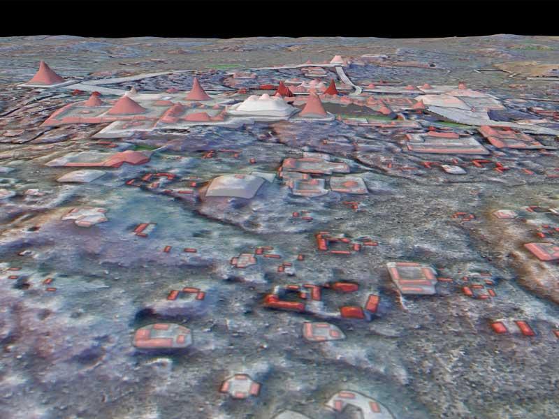
A team of archaeologists led by Tulane University has discovered how to track wealth and status in ancient Maya society: mapping vaulted structures in both urban and rural settings using jungle-penetrating lidar (light detection and ranging) technology.
Through the technology, researchers identified 110,000 buildings in the central Maya lowlands of southern Mexico and northern Guatemala, with 30 percent of those structures featuring masonry architecture designs such as vaulted ceilings and arches.
Tulane archaeologist Francisco Estrada-Belli, PhD, the lead author of the study, which was published in the Journal of Archaeological Science, said the research represents the largest sample ever of structures using lidar technology in a single study.
"Being able to see the distribution of elite and non-elite residences on a big scale is giving us the key to unlock the structure of Maya urbanism."
Tulane archaeologist Francisco Estrada-Belli
“Noting that the average proportion of vaulted structures is 30% we can confirm quantitatively that vaulted structures are a good indicator of Classic Maya wealth and elite status,” said Estrada-Belli, a research professor at the Middle American Research Institute (M.A.R.I.) in the Tulane School of Liberal Arts.
Estrada-Belli, who specializes in the use of remote sensing and geographic information systems on early Maya civilization, conducted the study with Laura Gilabert, a doctor in architecture at the Universitat Politecnica de Valencia and a postdoc at M.A.R.I. in 2022; Juan Carlos Fernandez-Diaz, PhD, research assistant professor at the National Center of Airborne Lidar Mapping at the University of Houston; Ivan Šprajc, PhD, a professor in archaeology from the Slovenian Academy of Sciences and Arts; and Marcello A. Canuto, M.A.R.I. director and anthropology professor at Tulane.
“I am constantly astounded by the amount of information that can be extracted from lidar data,” Canuto said. “We are certainly demonstrating that lidar can provide more than just pretty images of ‘lost cities in the jungle.’ In this article, we show how combining archaeological survey, architectural analysis and lidar data yields insights into the structure and organization of ancient Maya society on a large scale.”
The study follows others that Canuto and Estrada-Belli have conducted using lidar technology. In a 2021 article published in the Journal of Anthropolgoical Archaeology, Canuto and Tulane PhD candidate Luke Auld-Thomas show how lidar data can assist researchers in getting beyond the limitations placed by the tropical forest environment in which Lowland Maya archaeology occurs.
In 2018, Canuto and Estrada-Belli were part of a team of researchers who received international media coverage for their remarkable discovery of dozens of ancient cities in Guatemala using lidar technology. The discovery in the Peten forest of Guatemala included more than 60,000 structures, including isolated houses, large palaces, ceremonial centers and pyramids.
Lidar technology is able to bypass thick forest canopy and map features on the earth’s surface. The maps can often reveal changes in elevation, enabling archaeologists to identify human-made features on the ground, such as walls, roads or buildings.
“In this study we discover and test a new procedure for detecting masonry vaulted structures, which we typically associate with the elite in Maya archaeology, on lidar maps,” Estrada-Belli said. “Our test with a sample of excavated data from Tikal returned a 93% success rate.”
Researchers then applied the method to 110,000 structures distributed over 2,500 square kilometers of lidar maps.
The team found that many elite and non-elite structures cluster around elite residential plaza groups forming neighborhoods and districts. In addition, Maya elites consistently located themselves among the general population in both urban and rural areas to oversee the use and exchange of resources.
“This spatial arrangement likely favored flow of resources through every level of the social hierarchy and through different environmental zones to improve overall system efficiency and sustainability.”
“Maya neighborhoods have been notoriously difficult to define until now,” he said. “For me, one of the most surprising results of this study is that being able to see the distribution of elite and non-elite residences on a big scale is giving us the key to unlock the structure of Maya urbanism.”

