Hi-tech photos track Amazonian tree loss
The functioning of tropical rain forests, particularly the vast Amazonian forest, is a crucial factor for global climate, and accurately calculating deforestation is important for understanding relationships between the forest and trends in climate. Tulane ecologists monitoring tree losses in Amazonia rely on spectral images taken by Landsat satellites orbiting overhead.

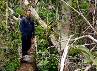
Postdoctoral fellow Robinson Negron-Juarez stands on the trunk of a fallen tree in the Amazon rain forest. It is an example of a small blowdown of trees researchers identified by analyzing satellite photos. (Photo from Robinson Negron-Juarez)
With these images, researchers can readily identify large areas of tree loss, such as fields cleared by farmers or large expanses of trees blown down by windstorms, says Robinson Negron-Juarez, a postdoctoral fellow, and Jeffrey Q. Chambers, assistant professor, both in the Tulane Department of Ecology and Evolutionary Biology.
But the Tulane team realized that small gaps in the forest numbering just a few trees were eluding detection due to the limits of image resolution. They are often smaller than the size of a single Landsat pixel.
“We have worked in the forest for a long time, and we know that in fact there are a lot of small disturbances everywhere,” says Negron-Juarez. The numerous small gaps, usually caused by powerful downbursts of wind, ought to add up to a considerable number of trees lost.
The team analyzed the spectral signature of forest blowdowns, which enabled them to identify individual small disturbances in Landsat images. To test their method, the team randomly selecting several single pixels identified in the images as small treefall gaps.
“Then we traveled to the Amazon and tracked down these pixels. It happened that they were in fact disturbances,” says Negron-Juarez. “When we added them up, these little disturbances were equivalent to 40 percent of the deforestation for the year when we did the analysis. It's a huge amount, and nobody had considered this at all before.”
Negron-Juarez and his colleagues recently published their study results in Remote Sensing of Environment.
