Online Flood Map Tracks River Crisis
Tulane University's Disaster Resilience Leadership Academy has launched an interactive website that allows residents in areas affected by Mississippi River flooding to post real-time information about how the disaster has affected their communities.

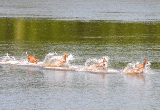
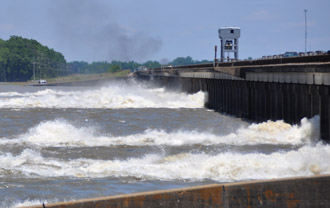
Deer run to escape water from the Morganza spillway in Louisiana, opened to relieve pressure on Mississippi River levees. (Photos from Louisiana Department of Wildlife and Fisheries)

As of Thursday (May 19), the Army Corps of Engineers had opened 17 bays of the Morganza spillway, flooding the Atchafalaya Basin.
The DRLA Louisiana Flood Map uses the open source Ushahidi crisis mapping software.
“The purpose of the map is to empower citizens of flood-affected Louisiana to speak out about how the flood is affecting their lives and livelihoods, their communities and the environment,” said Ky Luu, executive director of the Disaster Resilience Leadership Academy, which is affiliated with Tulane Law School.
The site collects and displays news, text messages, cell-phone photos, short videos and voice messages about the effects of the flooding submitted by Louisiana residents via their phones, email, Twitter and the Internet.
Residents can send photos, videos and text reports on water levels, flooded property, health effects, public safety issues, community resources, volunteer information and resources for flood protection and recovery. All reports are screened, categorized, geolocated and rendered on the online map in a timeline and in categorized lists.
Residents can report information in one of four ways: send a text message to 702-582-5378; e-mail; or send a tweet with the hashtag #lafloodmap or online at http://lafloodmap.drlatulane.org/reports/submit/
The site is similar to the Oil Spill Crisis Map the DRLA created with the environmental advocacy group Louisiana Bucket Brigade to track the effects of last year's Gulf oil spill. The map generated more than 3,400 reports ranging from spotting oiled wildlife to opportunities for community organizing.
“With crisis mapping we have the possibility of getting reports from anyone who notices a problem whether it's on the ground, from the air or via a satellite,” says DRLA co-director Nancy Mock. “It represents an amazing situational awareness tool. We can get better insights into the effects of disasters because the information comes from those affected by crises in near real time."
