Shifting Sands
During the months following Hurricane Katrina, Tulane geologist Stephen Nelson extensively researched the New Orleans-area levee failures. In November 2005, Nelson began offering field trips to the breach sites, calling the trips, “Hurricane Katrina What Happened?”

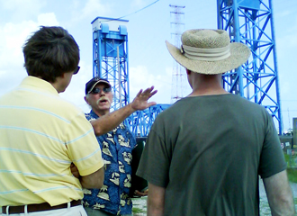
Geologist Stephen Nelson, center, conducts a Hurricane Katrina field trip, stopping at the floodwall along the Industrial Canal in the Lower Ninth Ward. (Photo by Belinda Lacoste)
Nelson has taken thousands of people on more than 200 field trips since the storm. During the academic year, students in Nelson's “Natural Disasters” and TIDES courses participate in the educational outings, which he still hosts nearly every other weekend.
“In New Orleans you don't necessarily see the geology exposed at the surface,” says Nelson, chair of the Department of Earth and Environmental Sciences. “But this field trip points out how important it is to understand what's there.”
Nelson begins the field trips with a history of the Mississippi River Delta complex. Before the land New Orleans is built on was formed, the Gulf of Mexico reached all the way to the north shore of Lake Pontchartrain. Ancient barrier islands, the Pine Islands, stretched into the Gulf from the east and still lay buried under portions of the New Orleans area.
During a field trip stop in the lower 9th Ward, at the newly built concrete floodwall, Nelson describes how overtopping during Katrina eroded the soil on the residential side of the levee, causing the floodwall and 3/4-inch-thick sheet pilings to loosen and give way.

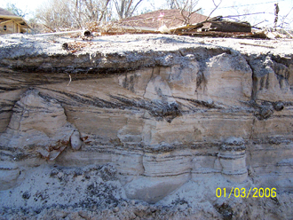
This sand deposit was formed when the levee on the London Avenue Canal breached after Hurricane Katrina, and sand was carried into the surrounding neighborhood. (Photo from Stephen Nelson)
At the London Avenue Canal east side breach, Nelson says canal water penetrated the highly permeable Pine Islands sand layer under the levee. Water moving below the sheet pilings and up to the surface eventually undermined and completely removed a section of levee.
This blowout caused roughly one million cubic feet of sand to be carried out by floodwaters from the breach and spread like a delta throughout the adjacent neighborhood. To prevent this siphoning effect, sheet pilings should have been driven to about a 40-foot depth, below the sand and into a layer of clay, he says.
Nelson's research of the site resulted in the only published study of this unique sand deposit. The article appeared in GSA Today in September 2006.
Belinda Lacoste is a student studying journalism in the School of Continuing Studies and a staff member who writes for the School of Science and Engineering.
